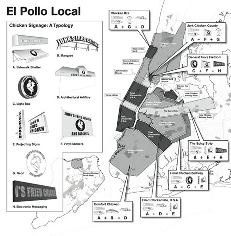
IMAGE: “El Pollo Local,” designed by Evan Allen — click here to see a larger version.
Another little treat from the New City Reader Food issue, “El Pollo Local” is a more light-hearted take on the idea of tracing New York City’s urban ecology of information.
Fried chicken is ubiquitous in inner-cities, but is also geographically differentiated. At street-level, through blinking neon signage and vinyl banners, it seemed to me that culinary variations in fried chicken must also map the global origins and palates of New York City’s residents onto the urban grid.
So, to make this imaginary atlas of New York chicken geography, I gathered the names and addresses of the city’s crispy chicken vendors. Designer Evan Allen then carefully plotted each one onto a map, using business names supplemented with Google Street View visits to redistrict neighborhoods according to their dominant regional cooking style and associated signage.
The urban fried chicken is a migratory bird: Evan’s map is a twitcher’s guide to spotting its more popular incarnations, as well as an alternative way of understanding and navigating the edible city.
[NOTE: The initial concept, data mining, and words for “El Pollo Local” were by me; the concept was then fully developed by designer Evan Allen, who also created the map and drawings, and conducted the signage analysis. “El Pollo Local” was originally published in the New City Reader food issue, edited in collaboration with Will Prince and Krista Ninivaggi. You can now read the issue in full online.]

